FLUVIAL DEPOSITION - ENGINEERING GEOLOGY - StudyCivilEngg
FLUVIAL DEPOSITION
SUBJECT : ENGINEERING GEOLOGY
Deposition of sediment takes place when the velocity of a stream is abruptly reduced because of sharp change in gradient. It occurs where a river flowing smoothly along a steep mountain slope reaches the ground of minimum undulations or plains. Such deposition results in the development of semi-permanent landforms.
The fluvial landforms are developed by fluvial processes of overland flow and channel flow. Thus, rock fragments that are removed from country rock are transported by running water and deposited at favourable sites to form entirely different sets of landforms. A deposition at landform once formed, may be eroded with the result that a new generation of erosional landforms are developed, which we may observe in the present environment.
Alluvium
Alluvium is unconsolidated or semi-consolidated sediment of comparatively recent geologic age that was deposited by flowing water. It covers the bedrock floors of river valleys. Alluvial gravel rarely forms ridges; for example, Tapti Alluvium. Alluvium deposits may be 'Active Alluvium' and 'Redict Alluvium'. An active alluvium is that sediment now capable of being transported by the stream that flows on it and the depth of which is defined by the flood scour depth of the modern channel. The deeper and coarser alluvium that is not being excavated by the modern streams, is known as 'Relict Alluvium'.
Flood-Plain Deposits
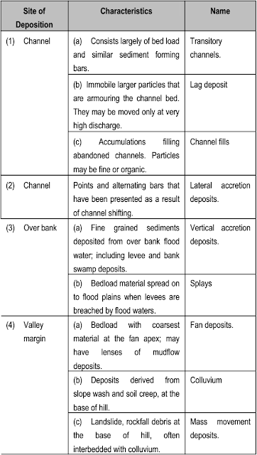
Sedimentation in flood-plain valleys is explained by lateral migration of channels across the flood plain and by over bank deposition during flood times. Each process gives rise to a distinct suite of deposits and related landforms. These are summarised in below table
 |
| Flood Plain Deposits |
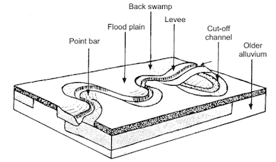
Flood-plains are built in two fundamental ways by lateral accretion and vertical accretion. Point bars (Below image) are the most important deposits of lateral accretion. As a meandering channel migrates across the flood-plain cut bank on the convex side is eroded. The derived load is carried a short distance downstream and deposited as a submerged bar, usually on the same side of the stream due to collapse of the convex side. This gives rise to point bars, a sub-dued relief of low ridges and intervening swales that contain record of many cycles of meandering channel migration. It is seen that deposition at point bars is controlled to a large extent by velocity of water and grain size of particles. The crest of point bars is usually close to the level of the flood-plain. The rate of migration of a meandering channel is a function of erodibility of a river. As a continuous process of migration, a meandering channel becomes increasingly sinuous untill it is cut-off either at the neck or in between two point bars to produce oxbow lake or mort lake. It is a temporary feature which eventually fills with organic matter and sediment deposited from overbank flows.
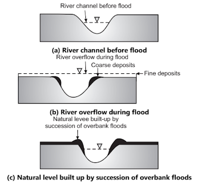
Large rivers with gentle gradients and an essentially suspended load typically have meandering channels on broad flood plains. When the river is in flood, the velocity in the overbank water may be very low and flood water may spill over slowly towards valley margins. Under these conditions, flood plain deposition is largely by vertical accretion. The abrupt loss of velocity at the edge of flooded channel cause coarser deposition on the natural levees (Below image) which grade laterally into backswamp deposits. The levees usually show an asymmetrical section with relatively steep banks against the river [Image (c)]. When levees extend well above flood-plains they may be breached during floods, called as a Crevasse and delta like deposit formed on the flood plain, known as crevasse splay.
 |
| Development of Natural Leeves |
Alluvial Fans
The deposits are largely composed of well developed rounded quartz with silts and clays. Flood plain valleys develop due to lateral migration and vertical accretion. Lateral migration occurs with both braided and meandering channels. Braided rivers normally change course when overbank flow spread on the flood plain as a result a new channel system is formed; while abandoned system becomes fossilised and may be filled with fine material and organic matter. Such channel changes tend to be catastrophic. Meandering channels migrate as the outer bank is eroded by undercutting and collapse, and on the inner side of a channel point bar deposition occurs in the form of a cross stratified deposit. The crests of point bars are usually close to the level of the flood-plain.
 |
| Geometry of Alluvial Fans |
The rate of migration of meandering channel is a function of erodibility of a river; e.g. the rate of lateral migration of Kosi river is 760 metres/year over several centuries; while in case of Brahmaputra it is 900 metres/year. An alluvial fan is commonly formed where a high flowing stream experiences sudden loss of velocity at the break of slope between very steep valley wall and the flood-plain.
A cone-shaped mass of coarse alluvium with an apex at the point where the stream leaves the mountain slope, gradually accumulates. Their surface morphology is characterised by radiating, branching distributary channels most often braided than meandering. Fans are agradational. One radial channel may carry most of the discharge until its gradient becomes over steep by deposition, and the stream may abruptly shift to a low gradient radius. As a continuous process, a uniform conical form is developed because of homogeneous development along all radii. Alluvial fans are characteristic of glacial or arid intermountain regions.
Deltas
Deposition in a flood-plain of a river is often temporary and as an end-process most of the sediment load is carried into the sea or to a lake. Here, the velocity of the running water is checked and a major part of the load is deposited in a triangle-shaped area with apex pointing upstream. The part of the delta which stands above water level is actually a continuation of a flood-plain and is built outward into the sea by successive accumulation of load. Not all deltas have the same shape. The shape is influenced by river discharge and load, grain size, flood frequency and intensity, climate, salinity, temperature etc.
 |
| Delta Profile |
The cross-section of a simple delta shows three basic depositional features: bottom set beds, foreset beds and topset beds. The foreset beds are made up of the coarser material and each bed is inclined. The bottomset beds are accumulated beyond the foreset beds and consist of thin, horizontal to sub-horizontal lamellae of fine grained sediments while the top set beds, consist of the coarse material of horizontal disposition.
Fluvial Terraces
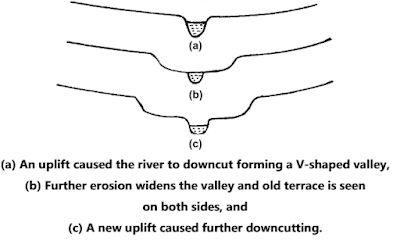
Most flood-plains have a low relief surface like a succession of steps rising up the valley sides. The surface of each terrace demarcates, the position of the floodplain at an earlier stage in the history of a river valley.
 |
| Fluvial Terrace |
Alluvial or fluvial terraces may represent aggradation alternating with downcutting and as a result of continuous erosion, the terraces themselves are relics of earlier floodplain. Thus, the higher terraces are older and are formed when the river had flowed at its highest level. It is important to note that fluvial terraces are cut, not built, by rivers. The studied fluvial terraces, their longitudinal profile may converge or diverge downstream. Convergence indicates possible rejuvenation because of tectonic uplift. Divergence indicates a progressive lowering of base level more rapidly than the average erosion rate. Generally, the alluvial (fluvial) terraces are fertile agricultural land which may easily be used for urban growth.
FAQs COVERED IN THIS POST
What is Fluvial Deposition?
What is Alluvium?
What are Flood Plain Deposits?
What are Alluvial Fans?
What are Deltas in Engineering Geology?
What is Fluvial Terrace?
What is Delta Profile
What is the Geometry of Alluvial Fans?
Describe the development of natural leeves with the figure
Describe the Flood Plain Deposits developed by Meandering Storm
What are different kinds of deposits and their characteristics?
RELATED POSTS
- SURVEYING - STUDY ONLINE
- BUILDING MATERIALS AND CONSTRUCTION - STUDY ONLINE
- FLUID MECHANICS - STUDY ONLINE
- SOIL MECHANICS - STUDY ONLINE


Post a Comment